🗺️ The Colouring Ghana platform is live! Start mapping buildings now →

Colouring Cities Research Programme · Ghana

Building data for a resilient future

Colouring Ghana is a free, collaborative research platform that collects, visualises, and shares open spatial data on Ghana's buildings, helping communities, government, and researchers make better decisions about our built environment.

Colouring Ghana Platform — interactive building data map
12 Data Categories
Open Licence (ODbL)
CCRP Global Network
KNUST Host Institution

What is Colouring Ghana?

Colouring Ghana is a research-led, free public resource providing open spatial data on Ghana's buildings and natural environment, built collectively by and for academia, communities, government, industry, and the third sector.

The platform enables individuals, communities, researchers, planners, and government agencies to collaboratively capture and share information about Ghana's buildings, from basic location and land use data to structural characteristics, age, energy use, and disaster vulnerability.

All data contributed to Colouring Ghana is released as open data under the Open Database Licence (ODbL), making it freely available for research, planning, policy-making, and education. No special skills are required to contribute. Anyone with local building knowledge can help fill in the map.

The project aims to build a rich, granular, and continuously updated national database of building attribute data to support evidence-based urban planning, climate adaptation, infrastructure investment, and disaster risk reduction across Ghana.

Explore the Platform →

🏛️ Host Institution

Department of Geomatic Engineering, Kwame Nkrumah University of Science and Technology (KNUST), Kumasi, Ghana.

🌍 Global Network

Colouring Ghana is one of many national platforms within the Colouring Cities Research Programme, which includes Colouring London, Colouring Dresden, Colouring Australia, and more.

📖 Open Data

All building data is free to use, share, and adapt under the Open Database Licence (ODbL). No registration required to view the data.

🔬 Research Focus

Urban resilience, climate adaptation, disaster risk reduction, sustainable development, and national spatial data infrastructure for Ghana.

What data do we collect?

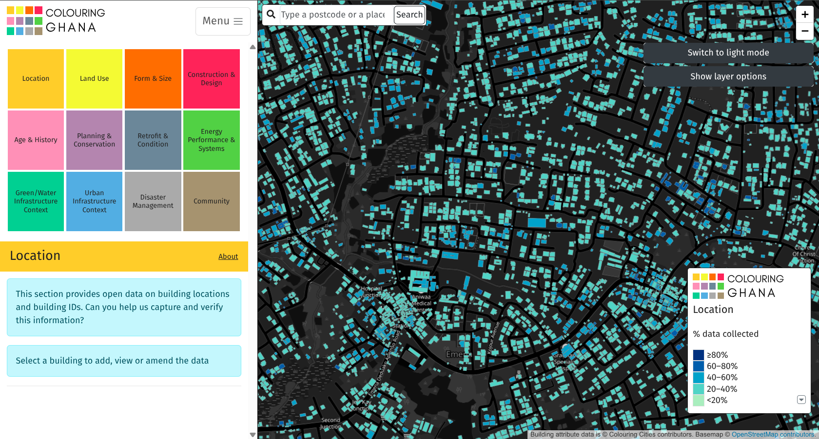
The platform captures 12 categories of building attribute data, colour-coded by theme and collaboratively filled in by contributors across Ghana.

Location Geographic coordinates, address, administrative unit, and references linking each building to maps and spatial data.
Land Use Current and historical land use — residential, commercial, institutional, agricultural, industrial, mixed-use, and more.
Form & Size Building type, number of floors, footprint dimensions, total floor area, and morphological form classification.
Construction & Design Materials, structural system, roof type, cladding, architectural style, and key construction details.
Age & History Construction date, decade, any significant modifications, and historical significance or heritage listing status.
Planning & Conservation Planning designations, conservation area, listed status, ownership, building condition, and regulatory context.
Retrofit & Condition Energy retrofit works undertaken, structural condition, and maintenance status.
Energy Performance & Systems Energy rating, heating/cooling systems, renewable energy sources, and performance data for Ghana's climate zones.
Green/Water Infrastructure Trees, permeable paving, rainwater harvesting, drainage infrastructure, and natural environment context.
Urban Infrastructure Context Proximity to roads, utilities, public transport and neighbourhood connectivity.
Disaster Management Flood risk zones, fire history, structural vulnerability, and resilience features critical for Ghana's hazard landscape.
Community Community importance scores, neighbourhood character, social or cultural importance, and resident-contributed knowledge.

The colour scheme mirrors the Colouring Cities Research Programme's shared framework. Each category can be explored independently on the platform.

How can you contribute?

There are many ways to help — whether you're on the ground, at a desk, or at a university. Every data point counts.

01

Register an Account

Create a free account on the Colouring Ghana platform. Registration only requires a username and password — no personal information is required.

02

Find a Building

Use the interactive map to navigate to any building in Ghana. You can search by place name or postcode, or simply zoom into your neighbourhood.

03

Add or Verify Data

Click a building to see what data has already been captured. Fill in missing fields or verify information you know to be correct.

04

Survey Your Area

Go for a walk in your neighbourhood and note building characteristics — construction type, number of storeys, approximate age — then add them to the map.

05

Share Your Knowledge

Have archival records, local history knowledge, or professional expertise in urban planning, architecture, or engineering? Your specialised knowledge is invaluable.

06

Organise a Mapathon

Bring together students, community groups, or colleagues for a collaborative mapping session. We can provide training materials and support for group events.

Start Contributing →

How to use Colouring Ghana

New to the platform? Follow this step-by-step guide to get started with mapping and contributing building data.

🗺️

Navigating the Map

Use the search bar or scroll/zoom to navigate. Buildings are colour-coded by data completeness. Click any building to begin.

👤

Creating Your Account

Click the Menu button at the top of the platform, then select Sign Up from the dropdown. Choose a username and password — providing an email address is optional. Your contributions will be attributed to your chosen username.

✏️

Adding Building Data

Select a category from the left panel. Click "Edit" to enter data. Use the category guide for help with each field. Save when done.

🔍

Verifying Existing Data

Browse buildings in your area. If existing data looks correct, confirm it. If incorrect, use the edit function to suggest a correction.

📊

Exploring the Data

Switch between data layers using the left panel. Use "Show layer options" to customise the map view. All data is downloadable as CSV.

📱

Mapping on Mobile

The platform works on smartphones — ideal for field surveys. Open the map in your mobile browser, log in, and add data on the go.

Ready to start mapping?

The Colouring Ghana platform is free and open to everyone. No prior experience in GIS or data entry is needed — just local knowledge and curiosity.

  • Visit the platform at the link below
  • Register a free account (takes under a minute)
  • Navigate to a building you know
  • Start with the "Location" or "Age & History" category
  • Add what you know and save your contribution
  • Share the platform with friends, students, or colleagues
Go to the Platform →

Viewing data does not require registration. An account is only needed to add or edit building data.

Why does this matter?

Ghana's rapid urbanisation demands better building data. Without it, planning decisions are made in the dark. Colouring Ghana changes that.

🌡️

Climate Adaptation

Understanding the age, materials, and energy performance of Ghana's building stock helps identify where retrofit interventions are most needed as climate pressures intensify.

⚠️

Disaster Risk Reduction

Detailed data on building construction type, condition, and location enables better assessment of vulnerability to floods, earthquakes, and other hazards common in Ghana.

🏙️

Urban Planning

Planners, municipal authorities, and government agencies gain access to granular, up-to-date data to support infrastructure investment decisions and spatial development plans.

🎓

Academic Research

The open dataset supports research in urban studies, architecture, civil engineering, geography, environmental science, and development studies across Ghanaian universities.

🌍

National Data Infrastructure

Colouring Ghana contributes to Ghana's national spatial data infrastructure, filling critical gaps in building attribute data not captured by existing national datasets.

🤝

Community Empowerment

Citizens gain agency over the data that describes their neighbourhoods. Communities can use the platform's open data to advocate for better services and infrastructure.

Who is behind Colouring Ghana?

The project is a collaboration between KNUST and the global Colouring Cities Research Programme network.

Host Institution

Kwame Nkrumah University of Science and Technology
Kwame Nkrumah University
of Science and Technology
Kumasi, Ghana
Department of Geomatic Engineering Leads the technical development and spatial data infrastructure of Colouring Ghana, managing the platform, overseeing data collection methodologies, ensuring geospatial data quality, and coordinating the programme's research activities.
Department of Planning Provides urban planning expertise and policy context, helping interpret building data for land use, development planning, and spatial governance, and bridging the programme's outputs with Ghana's planning practice and regulatory frameworks.

Research Programme

Colouring Cities Research Programme
Colouring Cities Research Programme (CCRP)a global network of open building data platforms hosted at Loughborough University, UK. The CCRP brings together academic institutions worldwide to co-develop interoperable open data platforms on buildings and the built environment.

Local Collaborator — Pilot Study Area

Oforikrom Municipal Assembly
Kumasi, Ghana

The Oforikrom Municipal Assembly (Kumasi, Ghana) is Colouring Ghana's inaugural government collaborator and the host of our pilot study. All building data currently on the platform covers the Oforikrom Municipal area. We are grateful for their support and look forward to expanding this partnership. We warmly welcome other Metropolitan, Municipal, and District Assemblies (MMDAs) across Ghana to join the programme and help build a comprehensive national building database.

International Collaborators — CCRP Network

Our closest African partner is Colouring Kenya — together we share data methodologies, research findings, and a common commitment to building open urban data infrastructure across the African continent. We also collaborate with Colouring Britain, Colouring Germany, Colouring Australia, Colouring Canada, and other CCRP platforms worldwide.

Contact the Team

We welcome enquiries from researchers, planners, students, community organisations, journalists, and anyone interested in contributing to or collaborating with Colouring Ghana.

Institution Department of Geomatic Engineering
Kwame Nkrumah University of Science & Technology
Kumasi, Ghana
Research Programme colouringcities.org
How to Contribute Register on the platform and start mapping. No prior experience needed.